|
Just
45 minutes from Taipei lies an unspoiled jungle
waiting to be explored. A river tracing adventure
awaits you in Wulai, on the Nanshi River.
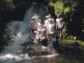
River tracing is fast becoming a popular sport
in Taiwan, which boasts abundant mountains,
rivers, streams and creeks. Some say the sport
began 40 years ago in Italy, and was brought
to Taiwan by Japanese sportsmen in 1981. Dave
Freeman, organizer of TOA Sports, a group
that runs summer camps, is one who has embraced
the activity.
"River tracing is not new," Freeman
explains. "It just recently acquired
a cool name." Also known as brook walking
or waterfall hunting, it allows the adventurer
to access otherwise inaccessible, untouched
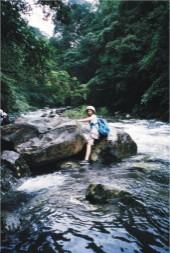
jungle. To put it simply, river tracing is
following a river up the side of a mountain
while wading through small rapids, climbing
over rocks and other obstacles, to venture
into untouched territory.
You don't have to go far to try this sport.
And you don't have to be an expert climber.
Freeman has led river-tracing trips with kids
as young as 10 years old. When it comes to
river tracing, there is something for everyone.
Essentially, the steeper the climb, the greater
the danger. New climbers should find an easy
route first and hike up a small creek.
As you're going to be in and out of the water,
Freeman recommends buying an airtight dry
bag and filling it with a change of clothes,
drinking water, and other essentials.
It's also important to wear the right type
of shoes. River-tracing boots are ideal, but
most people can get away with a good pair
of old tennis shoes. Clothing depends on the
weather; usually shorts and a T-shirt, but
some folk prefer wetsuits.
Directions
to Wulai:
By
Rachel Lanning and Dave Freeman Translated
by Batty Liu
Hop
on a bus at Xindian MRT station and head to
Wulai. About two-thirds of the way there,
you'll come to Zhongzhi Village Village up
on the hill to your left. Once you pass this
town, you need to start looking for a small
road on your right leading down into a valley
called Honghegu; ask the bus driver to notify
you when you are approaching the Honghegu
bus stop. Walk down the small road to the
swinging bridge. Cross and take a right; keep
going until you come to some concrete steps.
Soon the concrete trail becomes a dirt trail.
Keep hiking until you get to the stairs headed
up the mountain.
Three routes start at the base of the valley
between Gaoyaoshan and Xiangtianhushan, next
to the Jiajiuliao River. If you have an entire
day, skip the mountain hike and get in the
water right away; if you prefer a quicker
route, you can go up the stairs until you
see a small path cut away to the right. Hike
along this path for about 30 minutes. At this
point, you hike back down to the river and
begin your wet adventure. You'll spend about
three hours tracing the river.
Websites Taiwan
Tourism Information:
http://202.39.225.132/jsp/Eng/html/search/index.jsp
TOA Sports: http://www.toasports.com/rivertracing/
www.rivertracing.com
|